Saturday, December 21, 2013

When to go fishing in winter

There's plenty of perch under the ice at Petrie Island
... ice fishing, that is.

The tributaries of the Ottawa River are frozen now, more or less. There's a rumour that the Rideau Canal will soon be open for skating, and the ice fishermen will also be getting impatient to practise their sport on the Ottawa River itself.

I came across a website that reports the current depth of the ice on the Ottawa near Petrie Island, a popular ice fishing spot. The ice there is already 10" (25cm) thick in places. This website is run by The Petrie Island Ice Fishermen's Association, PIIFA, an organisation that's been in existence for 10 years now.
It all started back in 2004 with a few ice fishermen sitting in a hut discussing ideas on how to combat the increase of vandalism, thefts and break-ins of that season. A few beers were shared and many ideas were tossed around. In the end, the group decided to start an association of ice fisherman. The main task of the association would be to bring hut owners together, so everyone could get to know each other and become a more tight-knit group for better security.
It has become, as they say, "huge" (and popular). Their website includes a fish catalogue, a page of wood stove recipes, and an Angler's Gallery of the proud fishermen with their catches.

The ice has to be 30cm thick before you are permitted to erect a hut on it. (Any day now.) All fishing huts must be off the ice by March 15th, but that leaves you plenty of time to catch fish till then.

Thursday, December 12, 2013

A future for the Chaudière Falls

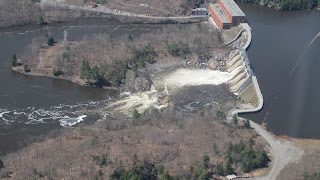
Chaudière Falls from the air, summer 2009
Great things are being planned, it seems, for the lands around Ottawa's Chaudière Falls, and about time too. Much of this industrial landscape has been lying there unused since 2005. The Windmill group of developers has signed a purchase deal with Domtar, who used to manage the site, and will turn the area into a major tourist attraction. Their plans include:
...establishing waterfront restaurants, cafés and public parks, setting up public gathering places that provide views of the river, building a mix of low-rise, highrise and affordable housing, redeveloping some of the heritage buildings, and creating various historical installations honouring the area’s logging and industrial history.
The company also says the project will be carbon neutral and will include on-site stormwater management, the use of solar, wind and other ecologically friendly systems. And it will be connected to a “safe and cohesive” pedestrian and cycle network, a “seamless” public transit system, and, to top it off, “an uninterrupted tourist experience.
It will offer marvellous views. Because much of the site is in the middle of the river, on the Albert and Chaudière Islands beside the falls, Windmill is calling its project The Isles / Les Îles and is intending to apply some Algonquin names to the new features; the Algonquin people, who are being consulted, have a historic claim to this land, which they see as sacred ground. A spokesman for Windmill promised they
would not neglect First Nations’ concerns. He pointed out that as part of its due diligence Windmill has already consulted with interested parties, including the Algonquins of Ontario and the Kitigan Zibi Anishinabeg band of Algonquins. Both groups have been positive in their responses to the company’s plans, he said.
(Ottawa Citizen)
"Various historical installations" within the new development will recall the site's logging history as well.

Tuesday, December 3, 2013

Back to winter

On our return, late on November 30th, we found the Rideau River already frozen over in our neighbourhood, with snow on the ice. It's an early winter in Ottawa this year. We missed a very cold week last week, apparently. The Ottawa River is still mainly clear of ice. The ducks and geese seem to have gone now.

The WaterStreet condo development has begun, with the old houses knocked down and the ground cleared for the new building work on Bruyère Street.

Here, for the sake of contrast, are some houses on the bank of the Parramatta River in Sydney, Australia (photo taken last week):


The westernmost of our Minto Bridges is under cover again, and a security guard sits there in his or her car day and night to keep guard over whatever is under the tarpaulins, which makes me wonder. Are we still in Phase 2 of the "rehabilitation" or is this the start of Phase 3? Possibly they're just doing more work on the new road surface. Anyhow, the road over the bridges is blocked again but at least pedestrians can get by on the boardwalk, unlike last year. We now have a small roundabout at the King Edward / Union street intersection, near the foreign affairs (Lester Pearson) building which will make for an easier flow once the Minto Bridges are open to traffic again.

Wednesday, November 13, 2013

A very distant river!

There won't be any blogposts about the Ottawa and Rideau Rivers this month because I'm in another hemisphere (failing to recognize the constellations after dark).

Riverbus stop on the Parramatta River


Sydney Harbour Bridge from Cockatoo Island
Yesterday we took river boats in both directions from Meadowbank to downtown Sydney on the Parramatta River estuary. The boats are like commuter busses, well used and frequent. Every few hundred metres there's a "bus stop" on the bank with its name (e.g. Kissing Point) visible from the river. We passed sandy beaches, sandstone cliffs and many wharfs, the wooden posts rotting away and covered with barnacles, the concrete posts less picturesque, but sturdier. Jellyfish rise and fall in the water. You can sit on the top deck of the catamarans in the sunshine and wind--hang on to your hat!--and watch the world go by. Houses on the riverbank look very desirable and are doubtless worth millions. Most have their own private fishing docks with watercraft anchored beyond them. In the distance are the Sydney skyscrapers.
Military style camping on Cockatoo Island

On our downriver ride we disembarked at Cockatoo Island, a former convict detention centre and shipbuilding yard which is undergoing a "Renaissance in every sense of the word" for the sake of the tourists. Indeed it was a fascinating place to explore, though the conditions for its poor inmates had been disturbingly harsh, and we were justifiably warned about the "aggressive seagulls" (with scarlet beaks and feet) that were nesting on the cliff face. Under the cliff was a field where tourists can camp in military tents overnight, if they wish, and on the other side of the island we found an ancient steam-powered crane, made in the 1880s.

The steam crane

Wednesday, November 6, 2013

The rocks beneath the Rideau

I had to ask, why all the little orange and yellow flags stuck in the grass in Bordeleau Park? What were all the men in fluorescent jackets doing with their measuring equipment? Why the floaters in the river and the large working boat laden with all its mysterious equipment? The answer is that a geophysical survey is underway to determine the depth of the bedrock in the riverside parks and underneath the river. They need to replace the ancient sewer that crosses the riverbed and services the districts on either side.

On the Rideau Canal website page I linked above, there's some history of the riverbed:
As the glaciers continued their retreat north, the St. Lawrence and Ottawa river valleys were exposed. The bedrock was depressed below sea level from the weight of the ice. This allowed waters of the Atlantic Ocean to fill the depressed area and mix with river waters and glacial meltwaters. This formed a brackish (partly salty) sea known as the Champlain Sea. This sea in the northern Rideau area lasted from about 12,000 BC to 11,100 BC and extended at least as far south as Rideau Ferry, perhaps to Nobles Bay of Big Rideau Lake. Evidence for this sea can be found in the sediments it deposited, including the Leda clay deposits found in the Ottawa area, many sea mollusc shells and even the bones of Beluga whales which have been found as far south as Smiths Falls. With the weight of the ice gone, the bedrock was rising, a process known as isostatic rebound. The rivers and lakes were establishing themselves.

Saturday, November 2, 2013

Controlling the flow

The website of the Ottawa River Regulation Planning Board, established in 1983 by the governments of Canada, Quebec, and Ontario to oversee the management of reservoirs of the Ottawa River basin, reports the daily water levels at various points along the Ottawa and the Gatineau Rivers, mentioning that, at present, "levels and flows on the main stem of the Ottawa River are slightly above normal for this time of the year." It also records the outflow from the Carillon dam in cubic metres per second (1700 at the last count).

The people most likely to be interested in these figures are the producers of hydro electric power in our region and the people vulnerable to floods. If there's too much or too little water flowing, one or the other of those groups is going to be affected.

Chelsea dam, Gatineau River
The dams on the Ottawa River and its tributaries are the places where the flow is controlled and the hydro electricity generated.
The combined capacity of the hydro-electric generating stations in the watershed is over 4000 MW, producing over $1 million worth of energy on a daily basis.
There are hundreds of dams and not all their effects are benefits. The Ottawa Riverkeepers list a few problems caused by dams:
  • Blocking upstream and downstream migration of fish and mussels, thereby preventing them from reaching spawning and feeding areas
  • Flooding, erosion, habitat washout
  • Scouring and armoring of the riverbed by infrequent and large releases of water
  • Rapid fluctuations in flow that do not mimic the natural flow patterns in rivers
  • Modification of water-quality parameters including water temperatures, nutrient concentration and dissolved oxygen.

November 1st by the Rideau River

It's a stormy time of year for the northern hemisphere. The wild weather and the clouds flying across the sky made me feel restless yesterday, so I went out twice across our local park to look at the river in the hope that it would calm me down.


Later in the day the park became covered in twigs, leaves and branches that had blown off the trees and the grey water was whipped into waves by the wind, gusting to >40 knots.

Thursday, October 31, 2013

Fresh air before the rain

After an early breakfast on Carling Avenue I had time for a short walk in Dick Bell Park by the Nepean Sailing Club before the rain started (and continued all day). It was cold (4º) but refreshing, with grey views of the Ottawa River, and nobody in the park apart than me and a solitary jogger. A small lighthouse at the mouth of the harbour guides the yachts to their docks in summer; not much need for it at this time of year when most of the yachts have been lifted to higher ground for the winter. The Nepean Sailing Club's website reports:
Despite the nasty weather, a large group of very dedicated volunteers were on hand this past Saturday to help haul about 85 boats. Tow-boat drivers, Radio-jockeys, Dock Crews, Shore Crews, Safety staff, Cradle placement teams, Layout planners [...] All in all, nearly 100 volunteers on hand in cold and wet conditions.
Geese were taking off from Britannia Bay this morning; they sleep on the river in large flocks by night then commute in family formations to the local cornfields by day.

My favourite Ottawa River view, as I've mentioned before, is the view from Dick Bell Park looking west, where the river appears to go on for ever, luring explorers upstream towards the wilds.


Wednesday, October 16, 2013

"Senseless rowing"

This is the clever title of a new blog being created by Dean Pucsek (previously mentioned here) who hopes to compete in the 2016 Paralympics as an oarsman and who's presently training daily at the Ottawa Rowing Club and on the Ottawa River. His description of what it's like to attempt this with impaired vision starts as follows:
Picture this, it’s 5:00 AM and you just arrived at the boathouse for your morning row. Getting out of the passenger seat you see small orbs of light floating mid-air, that must be the boathouse. As you walk towards the floating orbs you start to see other shapes, what are they? Likely the boathouse. Closer still, you can see a door under an orb. Yep, this is the boathouse. As you go around the front of the boathouse you see more floating orbs and hope the path to what you think are your team mates is clear. As you get closer to your suspected team mates you can hear voices that you recognize—nailed it. [...]
I am posting a link to Dean's blog from this site, so that I can follow his progress.

Good luck to him!

Sunday, September 29, 2013

The Thames and the Ottawa

London is a much bigger and more historic city than Ottawa, as you can tell from its river.

Central London

This is the view I had from Hungerford Bridge (the new footbridge) as I crossed the busy Thames from the south bank to the Embankment underground station, with St. Paul's Cathedral on the skyline and barges going under Waterloo Bridge.

Maybe in another few hundred years, Ottawa will look as developed as this, too. At the moment, it's still a relatively quiet place.

Central Ottawa


Flotsam

It's a month later, almost, and I have been away in Britain, near the Rivers Taff and Thames. While I was with my grandsons in London I read them the Canadian classic children's story, Paddle to the Sea (1941) about the boy who carves a model canoe with a man in it, and lets it float where it will from north of Lake Superior to the Atlantic, travelling gradually seawards on the currents. The story traces all the adventures of the wooden man in his canoe.

I had another bike ride by the Ottawa River yesterday, east of town this time, but I didn't see any tiny wooden canoes in the water. I did see plenty of boats making the most of our "Indian" summer and a fallen tree that had been carried downstream by the current recently, not too much of a hazard to the boating traffic if it's spotted in time.

Wednesday, August 21, 2013

Popular stopping points for Ottawa cyclists

Yesterday afternoon I rode my bike along the Ottawa River Pathway * (a 30km section of the Trans-Canada Trail), having arranged to meet my husband coming home from work on his own bike. His half-way point is near Mud Lake in the Britannia Bay area; I actually met him at Britannia Beach.
Located on the Ottawa River at Britannia Bay, the beach is great for swimming, picnics or just watching the sailboats go by on a beautiful summer day.
The city of Ottawa has a few more such recreational beaches. At three of them you can rent volley ball nets for $15 / hour and lifeguards monitor the bathing areas. We also passed the smaller beach without nets, at the Kitchissippi Lookout further downstream, where many commuting cyclists had laid their bikes on the sand and were sitting there taking a rest.

Britannia Beach: volleyball nets

Picnic at the old trolley bus station, June 2010
Britannia Beach feels like the seaside, with its yachts off the sandy shore, swimmers, pier and sun umbrellas. In the park are multiple barbecues and picnic tables. In the early 20th century this used to be a destination for day trips or cottage holidays for people from the city and was the terminus for a trolley bus ride (the line opened in 1900). The station roof is still there, now turned into a shelter for picnic tables. I had a stylish picnic here once with the ladies of the CFUW-Ottawa's Diplomatic Hospitality group. Yesterday a family was making use of it.

This year's rock sculptures
Closer to the city at the Remic Rapids are the numerous stone sculptures created (and photographed) anew each summer by the Canadian-Italian John Felice Ceprano and other "rock artists." They too are worth stopping for. It's best to stop there on your ride upriver because there's a gradual uphill most of the way in that direction; more opportunities for free-wheeling when you turn around and come back. Bring a camera!

Where we stopped on the way back was at the Mill Street Brew Pub near Victoria Island, Ottawa's oldest surviving mill, to have supper, with beer of course. It was packed with cyclists, to judge by the number of bikes stacked in the racks outside. The back of the restaurant overlooks a former log-chute channelling some of the water from the Chaudière Falls.

* The Ottawa River Pathway, intended for walkers, strollers and wheelchairs as well as bikes and rollerblades, is well maintained and signposted. It doesn't cross many roads, with underpasses under the main ones, but take notice of the stop signs at the minor roads and driveways. The major hazard is a sudden encounter with Canada geese wandering across the pathway. In summer time rush hour periods the trail is heavily used by cyclists commuting home from work, some of whom speed along at well over the 20kph speed limit, but they seem used to dodging the slower traffic and usually ring their bells if approaching fast from behind you. Informative plaques are posted at intervals along the trail if you have time to stop and read them.

Saturday, August 17, 2013

Magic on the river bank

It was the night of the Lumière Festival again, tonight: the Evening of Light Celebration in Stanley Park. It was a well supported event and free of charge. Little girls were swarming through New Edinburgh on their way to the park, dressed as fairies; it's a wonderful experience for all the children whose families bring them along. Some of the adults indulge in dressing up too. Lanterns hang in the trees along the river bank and monsters in the undergrowth glow from within. This year there were goose-lanterns by the path and swan-lanterns floating on the river as well as a crowd of rabbit-lanterns in the grass. People carry their home-made lanterns with them when they visit the park on this night. This month there have been nine lantern-making workshops on different days / times of day.

From the opposite bank of the Rideau you could distantly see the lanterns reflected in the water. The organisers were lucky this year (the 10th time the festival has been held) with perfect mild weather, not a breath of wind to blow out the candles and a full moon to enhance the atmosphere.

On our way home we saw two real swans under the St. Patrick Street bridge, one swimming decorously behind the other.

Tuesday, August 13, 2013

Different every time

My original motivation for writing these river posts was wanting to share the variety of what we notice on our more or less daily walks beside the Rideau. The river itself never looks the same as it did the previous evening and will look different again on the following evening. With the days getting shorter now, we're seeing the river at nightfall more frequently. In cloudy weather with no wind the other day, seen from the St. Patrick Street bridge it turned a dramatic shade of dark grey. Monday evening this week was finer, with a gentle breeze, and then the river looked like corrugated gold.

On evenings like this I'm reminded of the last chapter of a novel (published in 1910) by H.G. Wells, The History of Mr. Polly, which describes an evening by a nameless river in southern England:
... It was one of those evenings, serenely luminous, amply and atmospherically still, when the river bend was at its best. A swan floated against the dark green masses of the further bank, the stream flowed broad and shining to its destiny, with scarce a ripple––except where the reeds came out from the headland––the three poplars rose clear and harmonious against a sky of green and yellow.

"...what have we done," said Mr. Polly, "to get an evening like this? ... Sometimes I think I live for sunsets."

They ... sat on in the warm twilight until at last they could scarcely distinguish each other's faces. They were not so much thinking as lost in a smooth, still quiet of the mind. A bat flitted by ...

Friday, August 9, 2013

On the Mississippi

Mississippi River, Ontario, from the air
No, not that Mississippi, but the one in Ontario that flows into the Ottawa River at Fitzroy Harbour, northwest of the capital. We had a leisurely drive through Carleton Place and Almonte yesterday, both of which towns lie on the banks of this river. We also came close to Pakenham, where the river narrows again, further downstream. My aerial photo was taken over that area earlier this week, showing the Ottawa River in the distance.

In the other direction, southwest of Carleton Place, the Mississippi flows into the town from a sizeable lake: Lake Mississippi.

There's a curved weir in Carleton Place near the site of a former mill and Almonte / Mississippi Mills has a whole series of waterfalls (the river drops 65 feet on its way through the town) as well as its own textile mills. In fact it used to be known as The Manchester of the North. A new board walk with fences, steps and bridges, right beside the rapids, makes an impressive addition to the central part of the town.

The waterfalls below Bridge Street, Almonte
In Carleton Place as well as Almonte you can sit at patio tables belonging to restaurants on the banks of the Mississippi. The main through road, in both towns, is called Bridge Street. I wonder who copied whom.

Sunday, August 4, 2013

A Sunday bike ride

Another day of occasional summer showers today; we only needed to shelter once on our ride to the Hogs Back Falls. The trail from New Edinburgh follows the Rideau River all the way, only winding a short distance from it at the end to zigzag through a sloping field. We kept pedalling until we reached the outdoor "Cantina" at the Falls, now a Lone Star outlet, where we stopped for some lunch and took a look at the Falls, then turned around and pedalled back the way we'd come. We could have crossed the Hogs Back Road bridge and returned beside the Rideau Canal, except that would have meant riding amongst the holiday traffic in town for the last few kilometres.

The 25km ride was fun and good for us, no doubt, with small uphills here and there to increase the heart rate. We passed ducks, geese, rapids and innumerable picnic tables in the parks. Many other cyclists were doing the same. In the Vincent Massey park where a large party of people were enjoying a barbeque, we noticed a stone monument telling passers by about the Canadian Workers Mourning Day (my birthday, April 28th) "in recognition of all workers killed and injured on the job."

The Capital Pathway network in our city extends for 236 kilometres, apparently. The distance we covered today was the same as my husband's (one way) cycle ride to work from downtown Ottawa to Kanata. That route is mostly beside the Ottawa River and also almost entirely on the NCC's recreational trails.

Thursday, August 1, 2013

A celebratory cruise

On Tuesday this week Chris and I had been married for forty years, and we celebrated on the river, inviting six friends to share a cruise with us on the electric Duffy boat owned by Au Feel de L'Eau. The little boat called BES I is kept from May-October at the Casino Marina in Gatineau. Look for the sign advertising Croisières as you come down the steps on the right hand side of the Casino building at the end of the Boulevard du Casino––and here's the boat:

Chris already on board, meeting Sylvie, Captain of the boat
The other vessels moored there are the temporary visitors' boats and the Aquataxi that also belongs to Sylvie and Jean-Marc, skippers of Au Feel de L'Eau.


The Aquataxi ferries passengers across the Ottawa River
from the Rideau Canal to the Museum of Civilisation and back
It is a tight squeeze by this dock, but the Duffy boat's manoeuvrability allows for neat parking and an easy embarkation. We carried snacks on board for supper, everyone wiping their shoes on a carpet before entering the boat which was beautifully carpeted and furnished with soft leather seats, and at 6pm we promptly set sail.

Chris steering
As soon as Sylvie had navigated her boat through the narrow channel into Lac Leamy, she let Chris take the wheel and served us wine from the first of three bottles provided by the company––wine glasses, plates and napkins were provided too. The best thing about the cruise is its quietness, the electric engine being so unobtrusive that all you're aware of is the lapping of the water against the hull. No engine fumes pollute the air, either! We had the bonus of perfect weather on Tuesday evening, but if we hadn't been so fortunate, the canopy and roll down blinds would have protected us from wind and rain, and that would have been a romantic experience too. As we cruised, we listened to music through the speakers: Ravel's Bolero (at less than full volume) and some piano music.

We took the canal from Lac Leamy to the Gatineau River, sailed under the Lady Aberdeen Bridge at Pointe-Gatineau and thence into the Ottawa River, upstream to the city, not turning around until we reached Victoria Island. On the return journey, the Aquataxi, after its last trip of the day, followed us home by the same route in reverse.

Entering the channel between Lac Leamy and the Gatineau River

Passing the Rideau Falls

Below Parliament Hill, half way through the cruise
We paid for two hours on the water, but Sylvie had noticed I'd been following Au Feel de L'Eau on Facebook and treated us to extra time, later posting a photo of me on their page:
Our Facebook fan of the month, Mrs Alison Hobbs, got an extra 30 minutes on her cruise for following us on Facebook. Congratulations and thank you, Mrs Hobbs.
Chris didn't steer all the time; I had a turn too, and Sylvie took over for some of the difficult sections, under the Rideau Falls for example, and for the docking procedures. On the return she let Chris take the boat through the mouth of the Gatineau where underwater rocks and shallows have to be avoided, with reference to markers in the river and the chart.

My turn to steer the boat, photo by Carol Hinde

We don't usually see the Falls from this angle!

The navigation chart

Sylvie keeping an eye on Chris at the wheel
At the end of the voyage we had the bonus of a beautiful sunset, as well, and as we set off to drive home, all the fountains down the Boulevard du Casino were floodlit.


Having spent such a splendid evening on the cruise, relished by everyone, I promised that I'd recommend this service as widely as I could. It won the bronze award in the Services Touristiques category this year (Grands Prix du Tourisme Québecois) and stands another chance of winning a prize next year.

Note to first time cruisers: Take advantage of the washrooms at the Casino before you embark or when you disembark because this is one thing the boat lacks. Parking at the Casino is free.

Sunday, July 28, 2013

A long wait for the flying machines

I thought this would have made a good blogpost, but I'm afraid we got tired of waiting for the show.

It was a beautiful sunny morning while we were sitting at the foot of the Rideau Canal locks (the Alexandra Bridge, which would have made a better vantage point, was closed to pedestrians for the day) staring across the Ottawa River along with a large crowd of other people, including patient children, many of whom had pedalled there on their bikes. There was a far bigger crowd on the other bank near the action, or what would eventually be action, ––"Be there at 11am to check out the flying crafts and prepare for takeoff!" it said on the website––but the launching of the home made flying machines during Ottawa-Gatineau's Red Bull Flugtag, didn't actually begin until midday or perhaps later. We had gone by then.
Pilots ... launch themselves off a 22-foot high flight deck in hopes of soaring into the wild blue yonder…or more often than not, plunging into the waters below. Flugtag, which means “flying day” in German, pushes the envelope of human-powered flight ... Teams are judged on flight distance, creativity of the craft, and showmanship.
We missed seeing the flops of the flying beaver and the giant banana. Having read the report in the Ottawa Citizen, we seem to have missed a lot of fun altogether.

The Au Feel de l'Eau Aquataxi had been offering special rides on this occasion to passengers who booked in advance. Anyone lucky enough to arrive by boat could have a closer view of the Flugtag show; we saw some boat owners showing off at high speeds in the vicinity. I see that one canoeist-spectator has left a comment about this on the CBC.ca website, saying:
We went by canoe to join a fotilla of hundreds to enjoy the day. Unfortunately, on the way back we seemed to be the only ones stopped by the police to check if we had safety gear aboard. When asked what are you doing about the boats going at speeds up to 140 km/hr in the river, they responded that according to the law, people can drive their boats at any speed. Yes, but if they do so in an unsafe manner in a crowded waterway like this, that is an offence I replied. Too bad tbe cops [...] seem to focus on canoes when it's the motorized craft that imperil others.

Sunset over the museum

This picture was taken on June 30th (the evening before Canada Day) is a view of the Ottawa River and Musée des Civilisations in Gatineau from Parliament Hill on the Ottawa bank. The view from The Hill is always worth seeing. In the distance are the Gatineau Hills.

At present an exhibition at the museum, called Portés par le Fleuve (Moving with the River) shows the history of another great Canadian river, the St. Lawrence, with which the Ottawa River eventually merges.
"The exhibition retraces the river’s historic path with the Iroquois' thousand-year presence on the land, Franco-Aboriginal alliances, growth of a French settlement in the St. Lawrence Valley and multi-ethnic European immigration for which Québec served as a gateway."
The exhibition is on until March 2014.

Thursday, July 25, 2013

Athletes on the water

An article in the Ottawa Citizen yesterday described two oarsmen who get up very early each morning to row on the Ottawa River. One of them, Dean, is the nephew of our friend Carol; I have mentioned him in a previous post in this blog. What the article doesn't say is that he's going to keep this up day by day until November (so he told us)!

Incidentally, the day after I published that previous blogpost the new docks that had been stolen from the Rowing Club in May were retrieved and returned safely to their rightful place.

Wednesday, July 24, 2013

One of our sunsets

Here is our view from the Minto Bridges last night, looking towards the Gatineau Hills.

Monday, July 22, 2013

Full moon over a full river

The thunderstorms on Friday left a lot of water on the ground and the Rideau River banks have since overflowed in places, which is unusual for midsummer. We walked out onto the boat launching dock in our park last night and I put a hand into the water which after the sunny day was as warm as water in a bath tub. Our walk had been longer than usual because we wanted to see how the flood had affected the Rideau Falls––we made a detour and saw the golden brown flood pouring over. The spray made a rainbow above the falls. The wind had dropped completely which made for perfect riverside conditions and the full moon, when it rose behind Cummings Bridge, was crystal clear. We'd seen the moon the night before as well, from the Minto Bridges, with families of geese swimming in a line in the moonlight, still awake.

Thursday, July 18, 2013

Bullfrog chorus

On our walk by the Rideau River yesterday evening we stopped to find out what a group of people were staring at over the wall by the tennis courts in Stanley Park. (50-60 years ago, this wall used to be one side of a swimming pool in the river, the Flat Rock Pool, also called Les Trois Piscines.)

The answer was bullfrogs, lots of them, sitting on the weeds in shallow water and making their distinctive noise. One of the human crowd was croaking in imitation; probably a mating call, we warned him. Looking carefully, we could see these large and rather ugly frogs blowing out the air sacs in their neck as they made the calls. Someone said that they eat smaller frogs; I hadn't known that.

This is how they sound:


Saturday, June 22, 2013

Dragon boats on the Rideau

This weekend, unfortunately a grey one, it's the "Tim Horton's" Dragon Boat Festival in Ottawa, and a friend of mine has been paddling in one of the boats, at Mooney's Bay on the Rideau. Her team didn't win, but she sent me the link to a blogpost by Ron Hay, who has written about the training, illustrating his post with several photos of the dragon boat team.

From the Dragon Boat website:
Filling a boat requires 20 paddlers, a steersperson, a drummer or caller, and a few spares. Mixed teams must have a minimum of 8 female paddlers. This does not include the drummer or the steersperson. All women’s teams must have all female paddlers, but may have a male drummer and/or steersperson. A PERSON MAY BE A MEMBER OF AND RACE FOR ONLY ONE TEAM PER CATEGORY.
  • The categories are WOMEN and MIXED.
  • A steersperson/drummer may paddle for one team and may steer/drum for more than one team.

Saturday, June 8, 2013

Water treatment at Lemieux Island

Open Doors: visitors explore the gallery
The Canadian Newsblog has also published a post about this. That journalist must have been one of the numerous visitors to the Water Purification Plant last weekend, when it opened its doors to the public. We cycled there along the riverside bike trails last Sunday, light rain notwithstanding. Geese and goslings got in our way.

Keefer
I noticed that the marble staircase of the Lemieux Island Plant building (opened in 1928) closely resembles the stairs in the Chateau Laurier; it was made of the same stone in the days when important buildings had to be elegant. Water engineers (Thomas Keefer was the first in Ottawa) were treated with great respect and their headquarters were correspondingly splendid. In the old days, formal banquets used to be held in the gallery on the top floor of the water treatment plant. It was an echoey space, so the noise of many conversations at these events must have been a problem.

A purification plant has been operating here since 1874. Steam pumps processing 10 million gallons of river water per day by means of reciprocating pumps and waterwheels, which were replaced (at the time of the 2nd World War) by centrifugal pumps and turbines.

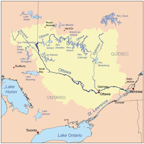
Simplified map of the watershed (Wikipedia)
Our group was led on a tour of the premises by Paul, the manager. To start with he showed us a wonderful map of the Ottawa River's watershed area. The water that flows through Ottawa comes from a 146,000 square kilometre area of land (drainage basin), of which the Algonquin Park, for example, is only a small part. There are few industries or conurbations in this area, so we are lucky to have water that's already relatively clean, although it's slightly coloured by the tannins from the leaves and grasses it touches.

In order to clarify and cleanse the raw river water, it goes through a series of processes including the addition of sulphuric acid to remove the aluminium in it.

Scum from "raw" water
The first stage is known as "coagulation / flocculation"––a stirring of the water in 8.5m deep tanks, which we saw, scum floating on the top. This removes the sediments in the water and 90% of its pathogens. The rest are filtered out through a deep layer of anthracite and (underneath it) quartz sand, a process lasting two or three days, after which the water is clear. The anthracite filter is effective for many decades, but has to be back-flushed regularly. Finally, the clarified water is disinfected with chlorine in order to remove viruses. Caustic soda (sodium hydroxide) is added at this stage to raise the PH level and prevent corrosion of the city's pipes. Another disinfectant, ammonia, goes into the water and a little fluoride is added for the sake of our teeth.

As an inducement to drinking tap water, free water containers were distributed and we were encouraged to take part in a blind water tasting––three kinds of drinking water being offered: distilled, bottled (filtered) and tap water. I could detect the different taste of the distilled water but there was little to distinguish the other two. Point made.

At the Ottawa Rowing Club

We know a young man (Dean Pucsek) who is training for the 2016 Paralympics, hoping to compete in the rowing team for the visually impaired. To be classed as a blind rower and eligible for the team, you must have
10% of vision in best eye with best correction (from visual acuity above 2/60 up to visual acuity of 6/60 and/or a visual field of more than 5% and less than 20%)
He gets up before sunrise every summer morning and cycles rather dangerously in the semi darkness to the Ottawa Rowing Club facilities at 10 Lady Grey Drive, on the river below Sussex Drive, to practise.

The Club has been in the news. In yesterday's Ottawa Citizen it was mentioned twice:
Two sections of the Ottawa Rowing Club’s new dock designed to make the sport more accessible to athletes with disabilities are missing and presumed stolen [on May 17th].
Four rowers were rescued from the Ottawa River Friday morning after their boat capsized. Paramedics, firefighters and police were called to the river near the Ottawa Rowing Club ...
Tomorrow, Sunday, June 9th, the Club will also be supporting volunteers who come to help clean up the shore line, as advertised by the Ottawa Riverkeepers:
Celebrate Canadian Rivers Day on the shores of the Ottawa River. Ottawa Riverkeeper is proud to welcome the Ottawa Rowing Club as new Riverwatchers! These keen and fit rowers have organized an exciting cleanup of the Ottawa River shoreline in downtown Ottawa. All participants are invited back to the beautiful Ottawa Rowing Club for a BBQ.
Come dressed to get wet and dirty! For your safety and comfort, we recommend that you wear a long-sleeved shirt and pants, canvas gloves, and rainboots.
Meet at the Bytown Museum, at 10 am.

Another heron

It's been a cloudy day followed by a grey evening, which deepens the shades of green along the river. After sitting on the seat in the park by the reinstalled, floating boat launch dock, and watching the fluff from the poplar trees drift by, we walked along the bank a little way and passed very close to where a heron was patiently waiting for fish. We'd previously seen the bird land on the branch of a riverside tree, flying low across the water and gliding into the tree very gracefully. It stood very still as we came close, perhaps feeling that if it didn't move, we wouldn't notice it. There was a mother duck, further along, with five ducklings. I'm afraid one of the ducklings might become the heron's supper, one of these days. Long and thin though the heron's neck is, it can easily swallow a duckling whole.

Friday, May 31, 2013

Moment of peace and quiet

After breakfast at Ralph & Sons' Diner on Carling Avenue I had the best part of an hour to kill, so drove to the nearby riverside park by the Nepean Sailing Club marina in Dick Bell Park, where I sat on a bench in the shade (it was already very hot), gazing upstream into the misty distance. What a pleasant way to start the day!

An exclusive enclave of homes is adjacent to the park, known as Rocky Point. I drove slowly down Rocky Point Road to explore it. A real estate advertisement for a house for sale says:
Welcome to this prestigious Crystal Bay/Rocky Point location surrounded by million dollar waterfront properties...
But there doesn't appear to be any public access to the water from there.

Wednesday, May 29, 2013

Mist rising, with herons

We went for a walk to the Rideau Falls after heavy rainshowers, this evening, and saw mist rising from the Quebec side of the Ottawa River, near the bank. It looked mysteriously beautiful, although something should be done a.s.a.p. about the dilapidated and defaced concrete walls around and below the falls.

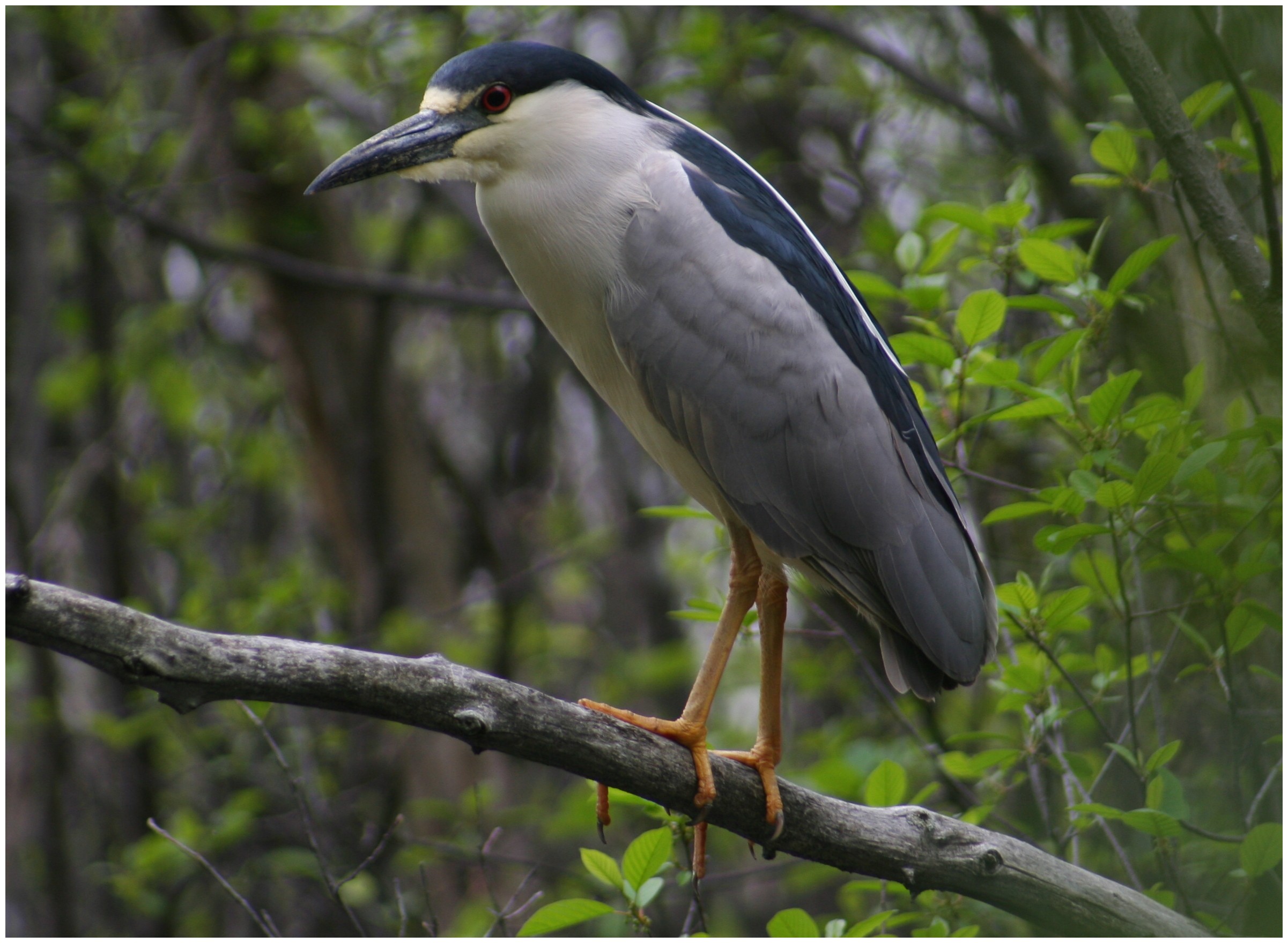
Seagulls and ducks were swooping overhead as usual and another bird glided onto the cliffs, that wasn't the right shape for a seagull. I think I have now identified it as a Black Crowned Night Heron (as pictured here, courtesy of the Wikipedia). In fact there was a pair of them.

 We also saw the more familiar kind of herons (the Great Blue) flying over the bridge and perching on the embankments. Ducklings and goslings on Green Island were being taken good care of by their parents.

Monday, May 27, 2013

Sunset at the end of the Rideau

A couple of evenings ago the change of light in the sky summoned us out of the house for a walk to the Rideau Falls, to see the sunset, and I took my camera with me. (My husband took the last of the photos below.) The fisherman commented on the number of goslings; they and their solicitous parents are often in the park as well, eating the grass, distracting walkers and making a terrible mess on the trails, but most of us like to see them. Ducks, seagulls and bats are everywhere too. The bats are feasting on the moths and mosquitos.